Those of you interested in urban memory, toponymy, cartography and Berlin may want to check out this great site by Hans Hack, which maps the traces of nineteenth and twentieth century conflicts in the street names of the German capital.
http://apps.dacosto.com/strassenkrieg/
Enjoy!
http://googlemapsmania.blogspot.de/2014/06/mapping-etymology-of-place-names.html

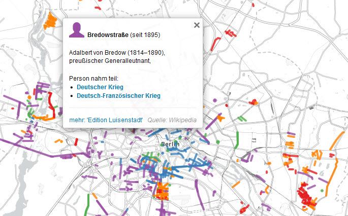
Straßenkrieg is a fascinating map revealing the history behind the many Berlin street names which have a military connection. The map highlights Berlin streets which have been named after battles, important military leaders or German army regiments.
All the military connected roads are highlighted on the map with colored lines. The colors indicate the historical period associated with the road's name, e.g. Prussian, the Weimar Republic, National Socialism or post-WWII. If you select a road on the map you can read a brief explanation of the military relevance of the road's name and click-through to read a more detailed account of the person or battle memorialized.

Straßenkrieg reminds me a lot of the History of San Francisco Place Names. The History of San Francisco Place Names is a fascinating insight into the history of the names behind the city's landmarks and streets.
Click on any of the streets or landmarks, marked in blue on the map, and you can find out who it was named after or where its name originally came from.
http://apps.dacosto.com/strassenkrieg/
Enjoy!
http://googlemapsmania.blogspot.de/2014/06/mapping-etymology-of-place-names.html
Straßenkrieg is a fascinating map revealing the history behind the many Berlin street names which have a military connection. The map highlights Berlin streets which have been named after battles, important military leaders or German army regiments.
All the military connected roads are highlighted on the map with colored lines. The colors indicate the historical period associated with the road's name, e.g. Prussian, the Weimar Republic, National Socialism or post-WWII. If you select a road on the map you can read a brief explanation of the military relevance of the road's name and click-through to read a more detailed account of the person or battle memorialized.
Straßenkrieg reminds me a lot of the History of San Francisco Place Names. The History of San Francisco Place Names is a fascinating insight into the history of the names behind the city's landmarks and streets.
Click on any of the streets or landmarks, marked in blue on the map, and you can find out who it was named after or where its name originally came from.
No comments:
Post a Comment